


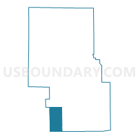
PERRY TOWNSHIP, Richland County, Ohio
About
Outline

Summary
| Unique Area Identifier | 651260 |
| Name | PERRY TOWNSHIP |
| County | Richland County |
| State | Ohio |
| Area (square miles) | 17.96 |
| Land Area (square miles) | 17.90 |
| Water Area (square miles) | 0.06 |
| % of Land Area | 99.67 |
| % of Water Area | 0.33 |
| Latitude of the Internal Point | 40.59421980 |
| Longtitude of the Internal Point | -82.59737900 |
Maps

Graphs
Select a template below for downloading or customizing gragh for PERRY TOWNSHIP, Richland County, Ohio


Neighbors
Neighoring Voting District (by Name) Neighboring Voting District on the Map
- JEFFERSON TOWNSHIP D, Richland County, OH
- MIDDLEBURY Voting District, Knox County, OH
- PERRY TWP N, Morrow County, OH
- PERRY TWP S, Morrow County, OH
- TROY TOWNSHIP B, Richland County, OH
- WASHINGTON TOWNSHIP F, Richland County, OH
Top 10 Neighboring County Subdivision (by Population) Neighboring County Subdivision on the Map
- Troy township, Richland County, OH (7,000)
- Washington township, Richland County, OH (6,428)
- Jefferson township, Richland County, OH (4,851)
- Perry township, Morrow County, OH (1,942)
- Perry township, Richland County, OH (1,456)
- Middlebury township, Knox County, OH (1,278)
Top 10 Neighboring Unified School District (by Population) Neighboring Unified School District on the Map
- Lexington Local School District, OH (16,317)
- Clear Fork Valley Local School District, OH (10,449)
- Northmor Local School District, OH (7,778)
- Fredericktown Local School District, OH (7,341)
Top 10 Neighboring State Legislative District Lower Chamber (by Population) Neighboring State Legislative District Lower Chamber on the Map
Top 10 Neighboring State Legislative District Upper Chamber (by Population) Neighboring State Legislative District Upper Chamber on the Map
Top 10 Neighboring 111th Congressional District (by Population) Neighboring 111th Congressional District on the Map
Top 10 Neighboring Census Tract (by Population) Neighboring Census Tract on the Map
- Census Tract 22, Richland County, OH (7,006)
- Census Tract 69, Knox County, OH (5,919)
- Census Tract 30.01, Richland County, OH (5,298)
- Census Tract 21.02, Richland County, OH (4,679)
- Census Tract 9651, Morrow County, OH (4,643)